Property Record
9 Nc 9 Hwy, Mill Spring, NC 28756

Save to a Folder
{{folder.Name}}
{{folder.ListingIds.length}} Properties
{{folder.ListingIds.length}} Property
Create a New Folder
Property Detail
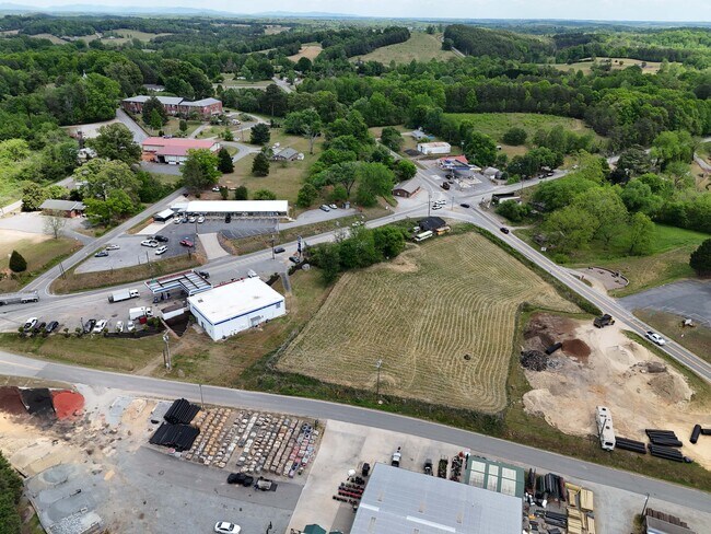
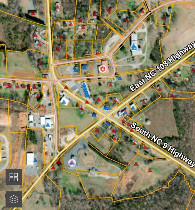
9 Nc 9 Hwy
MS-71A-D2
400B, 0000 00 X 00, 0BC02 BUS CLUST MILL SPRING
Realpropertynec
POLK
OPEN
North Carolina
B and X Area of moderate flood hazard, usually the area between the limits of the 100-year and 500-year floods.
2.42 AC
2025
North Carolina West/Cherokee Area
2025
Other Market Areas
920200
NEARBY LISTINGS FOR SALE OR LEASE
-
-
View all Mill Spring listings for sale on LoopNet.com
DEMOGRAPHICS near 9 Nc 9 Hwy
1 mile
3 mile
5 mile
2025 Total Population
281
1,818
7,759
2030 Population
288
1,865
8,004
Pop Growth 2025-2030
+ 2.49%
+ 2.59%
+ 3.16%
Average Age
47
48
48
2025 Total Households
121
785
3,333
HH Growth 2025-2030
+ 2.48%
+ 2.55%
+ 3.18%
Median Household Inc
$47,500
$55,624
$63,800
Avg Household Size
2.30
2.20
2.20
2025 Avg HH Vehicles
2.00
2.00
2.00
Median Home Value
$297,367
$316,935
$329,124
Median Year Built
1983
1986
1987
Nearby Places
Map Layers
Map Styles
 Street
 Aerial
Layers
 Traffic
 Biking
Places
Listings with unknown addresses are not visible on the map
- Restaurants
- Banks
- Shops
- Fitness
- Groceries
PUBLIC TRANSPORTATION
AIRPORT
Asheville Regional
Drive
Walk
Distance
Asheville Regional
39 min
31.2 mi
Greenville Spartanburg International
Drive
Walk
Distance
Greenville Spartanburg International
55 min
42.7 mi
Freight Ports
North Charleston Terminal
Drive
Walk
Distance
North Charleston Terminal
250 min
223.5 mi
Nearby Properties
Address
Land Use
TOTAL SIZE
Lot Size
Zoning
Address
Land Use
TOTAL SIZE
Lot Size
Zoning
63.34 AC
MX
Address
Land Use
TOTAL SIZE
Lot Size
Zoning
106,438 SF
156.87 AC
OPEN
Address
Land Use
TOTAL SIZE
Lot Size
Zoning
1,481.45 AC
OPEN
Address
Land Use
TOTAL SIZE
Lot Size
Zoning
29.43 AC
OPEN
Address
Land Use
TOTAL SIZE
Lot Size
Zoning
600 AC
Address
Land Use
TOTAL SIZE
Lot Size
Zoning
2,966 SF
11.53 AC
MX
Address
Land Use
TOTAL SIZE
Lot Size
Zoning
300 AC
Address
Land Use
TOTAL SIZE
Lot Size
Zoning
2,091 SF
78.81 AC
MX
Address
Land Use
TOTAL SIZE
Lot Size
Zoning
8.38 AC
Address
Land Use
TOTAL SIZE
Lot Size
Zoning
74,862 SF
7.93 AC
I
Address
Land Use
TOTAL SIZE
Lot Size
Zoning
8,870 SF
0.83 AC
MX
Address
Land Use
TOTAL SIZE
Lot Size
Zoning
19,759 SF
6 AC
MX
Address
Land Use
TOTAL SIZE
Lot Size
Zoning
Address
Land Use
TOTAL SIZE
Lot Size
Zoning
13.01 AC
Address
Land Use
TOTAL SIZE
Lot Size
Zoning
Address
Land Use
TOTAL SIZE
Lot Size
Zoning
7,534 SF
3.99 AC
OPEN
Address
Land Use
TOTAL SIZE
Lot Size
Zoning
3,600 SF
1.41 AC
HC
Address
Land Use
TOTAL SIZE
Lot Size
Zoning
2.54 AC
OPEN
Address
Land Use
TOTAL SIZE
Lot Size
Zoning
1,404 SF
507.84 AC
OPEN
Address
Land Use
TOTAL SIZE
Lot Size
Zoning
22.54 AC
OPEN
Address
Land Use
TOTAL SIZE
Lot Size
Zoning
137.56 AC
MX
Address
Land Use
TOTAL SIZE
Lot Size
Zoning
Address
Land Use
TOTAL SIZE
Lot Size
Zoning
10,340 SF
0.99 AC
OPEN
Address
Land Use
TOTAL SIZE
Lot Size
Zoning
674.69 AC
OPEN
Address
Land Use
TOTAL SIZE
Lot Size
Zoning
3,160 SF
4.29 AC
MX
Address
Land Use
TOTAL SIZE
Lot Size
Zoning
5,576 SF
4.67 AC
OPEN
Address
Land Use
TOTAL SIZE
Lot Size
Zoning
76.32 AC
MX
Address
Land Use
TOTAL SIZE
Lot Size
Zoning
3,675 SF
2.74 AC
OPEN
Address
Land Use
TOTAL SIZE
Lot Size
Zoning
864 SF
71.49 AC
OPEN
Address
Land Use
TOTAL SIZE
Lot Size
Zoning
3,575 SF
0.35 AC
The World's #1 Commercial Real Estate Marketplace
Connect with us
© 2026 CoStar Group
The information above has been obtained from sources believed reliable. While we do not doubt its accuracy we have not verified it and make no guarantee, warranty or representation about it. It is your responsibility to independently confirm its accuracy and completeness. Any projections, opinions, assumptions, or estimates used are for example only and do not represent the current or future performance of the property. The value of this transaction to you depends on tax and other factors which should be evaluated by your tax, financial, and legal advisors. You and your advisors should conduct a careful, independent investigation of the property to determine to your satisfaction the suitability of the property for your needs.